Doi Inthanon National Park
Chiang Mai, Thailand
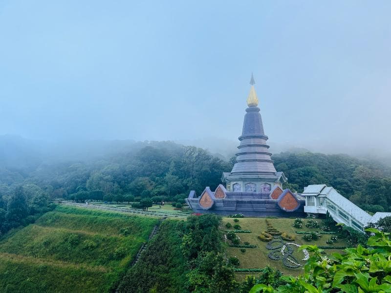
Discover Doi Inthanon National Park in Chiang Mai, Thailand – home to the country's highest peak, stunning pagodas, and lush nature.
Overview
Nestled in the picturesque mountains of Chiang Mai, Thailand, Doi Inthanon National Park offers a refreshing escape and a journey to the 'Roof of Thailand'. Covering 482 square kilometers, this majestic park is home to Doi Inthanon, the nation's highest peak, soaring to an elevation of 2,565 meters above sea level. Its high altitude creates a unique climate, offering cool temperatures and high humidity year-round, a welcome respite from the tropical heat of the lowlands. Visitors are drawn to its dramatic waterfalls, serene nature trails, and the profound cultural experiences found within its misty, forested landscapes.
History & Cultural Background
The mountain now known as Doi Inthanon was originally called Doi Luang, meaning 'large mountain,' or Doi Ang Ka, a name potentially linked to a swampy pond where crows gathered. The park and its central peak were officially renamed in honor of King Inthawichayanon, the last independent ruler of Chiang Mai, who reigned from 1870 to 1897. King Inthawichayanon was deeply concerned about deforestation in northern Thailand and passionately advocated for the preservation of its precious forests. Following his death, his ashes were enshrined at the summit, fulfilling his wish and cementing his legacy as a protector of nature. Doi Inthanon National Park was established as Thailand's sixth national park on October 2, 1972, encompassing a significant portion of the Himalayan mountain range. The park's slopes have also long been home to diverse hill tribe communities, including the Karen and Hmong people, who maintain traditional ways of life.
What Makes It Special
Doi Inthanon's designation as Thailand's highest mountain is just one of its many remarkable features. The park is renowned for its iconic Royal Twin Pagodas, Phra Mahathat Naphamethanidon and Phra Mahathat Naphaphon Phumisiri. These magnificent chedis were constructed by the Royal Thai Air Force to commemorate the 60th birthdays of King Bhumibol Adulyadej (in 1987) and Queen Sirikit (in 1992), respectively. Surrounded by exquisitely manicured gardens, they offer breathtaking panoramic views of the surrounding mountains and valleys, especially when a 'sea of clouds' blankets the landscape below. The park's diverse ecosystems range from moist evergreen cloud forests and sphagnum bogs at higher elevations to mixed deciduous forests lower down, supporting an astonishing array of flora. Unique plant species like various rhododendrons and numerous epiphytes thrive in the persistent mists near the summit. Doi Inthanon is also a premier destination for birdwatching, boasting over 300 to 500 species, many of which are not found elsewhere in Thailand. Popular nature trails like Kew Mae Pan and Ang Ka offer immersive experiences through moss-draped forests and unique montane environments.
Stories, Fun Facts & Local Details
The historical name Doi Ang Ka, or 'crow's pond top,' hints at the small, swampy pond near the summit where crows were once seen bathing. The region's traditional folklore describes it as the home of the Phiphannam, the 'spirit who shares water,' a testament to the mountain's crucial role as a watershed for central Thailand. A significant local detail is the impact of the Royal Project, initiated by the late King Bhumibol Adulyadej. This project helped local hill tribes transition from cultivating opium poppies to growing more sustainable commercial crops such as vegetables, fruits, and flowers, empowering communities and fostering economic stability. The cool climate at Doi Inthanon is a constant source of fascination; temperatures can drop significantly, often nearing freezing during the cool season from November to February, a stark contrast to the rest of tropical Thailand. Visitors often seek out viewpoints for the magical 'sea of clouds' phenomenon, particularly captivating at sunrise or sunset.
Visitor Perspective
Exploring Doi Inthanon National Park offers a memorable journey for curious travelers. Numerous well-maintained trails cater to various fitness levels; the Ang Ka Nature Trail provides an easy boardwalk stroll through a mystical mossy cloud forest near the summit, while the Kew Mae Pan Nature Trail offers a more extensive trek with stunning ridge-top vistas. The park is adorned with several magnificent waterfalls, each with its own character. Wachirathan Waterfall is impressive for its sheer power and often displays rainbows in its mist, while Mae Ya Waterfall cascades gracefully over multiple tiers, considered one of the country's most beautiful. Sirithan and Mae Klang Waterfalls also provide serene spots for contemplation. Engaging with the Karen and Hmong hill tribe villages provides insight into their unique cultures and crafts, with opportunities to see the success of the Royal Project. Birdwatching is a highlight for many, with the park offering unparalleled opportunities to spot rare species amidst its rich biodiversity. For those wishing to extend their stay, camping facilities are available, allowing for a deeper immersion in the park's natural tranquility.
Coordinates: 98.48667, 18.5875
View on Google Maps💬 How Travelers Describe This Place
Based on community votes
Beautiful
585Unique
546Photogenic
503Interesting
92Must See
56
Traveler Stories
Discover memorable experiences shared by travelers who have visited this place.
No traveler stories yet.
Be the first traveler to share what made this place memorable.
Things to see at Doi Inthanon National Park



Tour
By
Spot
Discover amazing places around the world. Your journey starts here.
Explore
© 2026 TourBySpot. All rights reserved.