Kew Mae Pan Nature Trail
Chiang Mai, Thailand
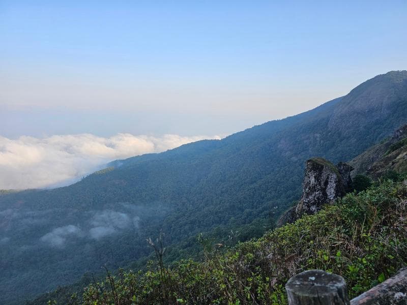
Explore Kew Mae Pan Nature Trail in Doi Inthanon National Park, Chiang Mai, Thailand. Discover cloud forests, panoramic views, and unique flora on this guided hike.
Overview
Nestled within the breathtaking Doi Inthanon National Park, the Kew Mae Pan Nature Trail offers an immersive journey through a diverse tapestry of ecosystems in Chiang Mai, Thailand. This popular, approximately 3-kilometer loop trail provides a moderate hiking experience, typically taking between 1.5 to 3 hours to complete. Situated at an elevation of around 2,200 meters above sea level, it stands as one of the highest and most scenic trails in the country, attracting nature lovers with its cool, crisp mountain air and unparalleled vistas.
The trail is renowned for its well-maintained paths, featuring both dirt sections and wooden boardwalks that protect the delicate natural environment while ensuring visitor safety. A unique aspect of the Kew Mae Pan experience is the mandatory accompaniment of a local Hmong guide, who shares insights into the surrounding flora and fauna, making it an educational and culturally enriching trek.
History & Cultural Background
The development of tourism within Doi Inthanon National Park, and consequently the Kew Mae Pan Nature Trail, has largely taken place over the last few decades. The trail itself was opened to the public around 1999, specifically designed as an 'educative nature trail'.
Its establishment reflects a growing appreciation for ecological conservation combined with sustainable tourism. The involvement of local Hmong communities as mandatory guides is a vital part of this model, providing economic opportunities and fostering a connection between visitors and the indigenous caretakers of the land. These guides, while sometimes having limited English proficiency, offer a presence that ensures the protection of the delicate ecosystem and contributes to the local economy.
What Makes It Special
What truly sets the Kew Mae Pan Nature Trail apart is its incredible ecological diversity condensed into a relatively short hike. The trail winds through three distinct stages: starting with a dense, misty cloud forest, transitioning into expansive sub-alpine grasslands, and concluding in tranquil woodlands.
The cloud forest section, rich with ancient ferns, mosses, and various orchid species, acts as a critical watershed, trapping moisture from the clouds. As hikers emerge from the forest, they are greeted by rolling grasslands that offer breathtaking panoramic views of the surrounding mountains and valleys. This stark contrast between the dense forest and open meadow highlights the varied ecological conditions along the ridge. The trail is also famous for its vibrant red rhododendrons, a rare sight in Thailand, especially when in bloom during the dry season. Keep an eye out for the elusive goral, a goat-like animal adapted to the rocky cliffs, often sighted from designated viewpoints.
Stories, Fun Facts & Local Details
The Kew Mae Pan Nature Trail serves as a living outdoor classroom, featuring 21 numbered stations along its path, each with interpretive signs in both Thai and English. These signs explain the unique landscapes, ecosystems, and specific plant life encountered at each point, offering a deeper understanding of this high-altitude environment.
One intriguing feature is the mountain ridge itself, which strikingly divides the forest into two different ecosystems. On one side, lush greenery thrives, while the other slope, exposed to harsher winds and sun, supports more stunted vegetation. This natural boundary is a powerful illustration of nature's adaptability. Along the way, hikers might encounter Larn Sadet Waterfall, which was affectionately renamed 'The Queen's Visit' after a royal visit, adding a touch of historical reverence to the natural beauty. Local folklore sometimes points to specific rock formations, like the 'Lover Stone' twin rocks, attributed to ancient tectonic forces, adding a layer of myth to the natural wonders.
Visitor Perspective
The Kew Mae Pan Nature Trail provides an unforgettable experience for those seeking a deeper connection with nature. It is generally open from November 1st to May 31st each year, closing during the rainy season (June to October) to allow the forest to regenerate and for safety reasons due to slippery conditions and reduced visibility.
Visitors are required to hire a local Hmong guide at the trailhead, with a fee of approximately 200 baht per group, which ensures both a guided experience and support for the local community. The trail's moderate difficulty means it is accessible to most, though some uphill sections and stairs require a reasonable level of physical fitness. Comfortable walking shoes with good grip are highly recommended. Early morning visits are particularly rewarding, offering cooler temperatures and the chance to witness the spectacular 'sea of clouds' phenomenon over the valleys, providing exceptional photographic opportunities.
Coordinates: 98.48235, 18.55555
View on Google Maps💬 How Travelers Describe This Place
Based on community votes
Interesting
747Unique
399Photogenic
302Must See
182Beautiful
76
Traveler Stories
Discover memorable experiences shared by travelers who have visited this place.
No traveler stories yet.
Be the first traveler to share what made this place memorable.

Tour
By
Spot
Discover amazing places around the world. Your journey starts here.
Explore
© 2026 TourBySpot. All rights reserved.