Hiking Trails
San Francisco, United States
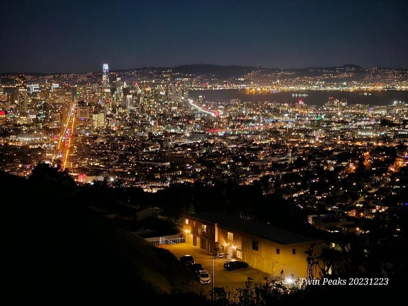
Explore Twin Peaks' hiking trails in San Francisco, United States, for stunning 360-degree views, rich history, and unique wildlife.
Overview
Perched majestically in the geographical heart of San Francisco, the hiking trails of Twin Peaks offer an unparalleled opportunity to experience the city's breathtaking beauty. These two prominent hills, rising to an elevation of approximately 925 feet (282 meters), are the second and third highest natural points in San Francisco, surpassed only by Mount Davidson. From their summits, known individually as Eureka Peak (North Peak) and Noe Peak (South Peak), visitors are treated to stunning 360-degree panoramic vistas that sweep across the entire Bay Area.
The Twin Peaks area encompasses a 64-acre natural park, providing a vital green space for both residents and travelers seeking an escape into nature within the urban landscape. The primary trail network here covers about 0.7 miles, guiding hikers to the top of both peaks. For those desiring a more extensive adventure, these trails seamlessly connect to larger networks, including the 1.8-mile (one-way) Creeks-to-Peaks Trail from Glen Canyon Park and the expansive Bay Area Ridge Trail, offering diverse hiking options. Recent improvements have enhanced the trails, and a significant portion of Twin Peaks Boulevard is now permanently closed to vehicles, creating a dedicated space for pedestrians and cyclists to enjoy.
History & Cultural Background
Long before San Francisco became the bustling metropolis it is today, the Twin Peaks held deep significance for its earliest inhabitants. The native Ohlone people are believed to have utilized these elevated points as crucial lookouts and fertile hunting grounds. With the arrival of Spanish settlers in the early 18th century, the peaks were given the descriptive name 'Los Pechos de la Chola,' translating to 'Breasts of the Indian Maiden,' and the land was subsequently used for ranching.
As California transitioned into American control, the more universally recognized name 'Twin Peaks' was adopted. Beyond their practical uses, these hills are steeped in local folklore; an enduring Ohlone legend recounts how the peaks were once a single mountain, tragically split apart by a Great Spirit after a persistent argument between a husband and wife. This rich history adds layers of meaning to every step taken on these ancient slopes, connecting hikers to centuries of human interaction with this remarkable landscape.
What Makes It Special
The allure of Twin Peaks lies in its extraordinary blend of natural beauty and urban panorama. What truly sets these trails apart is the breathtaking, unobstructed 360-degree view that unfurls from the summits. From this vantage point, iconic landmarks such as the Golden Gate Bridge, Alcatraz, the bustling downtown skyline, and the vast expanse of the Pacific Ocean are all visible, creating a visual tapestry of San Francisco's grandeur.
Moreover, Twin Peaks is a vital ecological haven. It is home to the federally endangered Mission Blue Butterfly, a delicate species that has uniquely adapted to the area's strong winds, fluttering low among the native lupine plants where it lays its eggs. The surrounding coastal scrub and grassland communities provide essential habitat for a diverse array of wildlife, including brush-nesting birds, elusive brush rabbits, and even coyotes. The peaks also play a fascinating role in San Francisco's microclimates, acting as a natural barrier against the persistent summer fog. This results in distinct weather patterns, with the west-facing slopes often shrouded in fog and buffeted by strong winds, while the east-facing slopes bask in more sun and warmth. The recent transformation of parts of Twin Peaks Boulevard into car-free zones further enhances the special pedestrian and cycling experience, allowing for serene enjoyment of this natural wonder.
Stories, Fun Facts & Local Details
The two distinct peaks, Eureka and Noe, stand approximately 660 feet apart, each offering its unique perspective on the city below. For photographers and view-seekers, timing is everything: the magic hours of sunrise or sunset offer particularly stunning, 'Instagram-worthy' photo opportunities. Even on foggy days, the diffused light can create a dramatic and atmospheric scene for capturing memorable images.
A practical tip for any visitor is to always come prepared: wear sturdy, comfortable shoes and dress in layers. The exposed nature of the peaks means that strong winds and sudden shifts in temperature are common, even on otherwise sunny days, and the weather at the summit can be surprisingly different from street level. It is crucial to remain on marked trails to protect the delicate ecosystem, prevent erosion, and avoid encountering poison oak, which can be present off-trail. Interestingly, to the north of Twin Peaks lies a specialized reservoir, part of the San Francisco Fire Department's unique high-pressure water system designed for combating fires in the city's hilly terrain.
Visitor Perspective
Most visitors find that a typical visit to Twin Peaks lasts between 30 minutes to an hour, offering ample time to soak in the views and enjoy a short hike. Accessing the peaks is flexible: while driving remains an option (with some road closures and car-free zones to be aware of), public transportation is also available, with the 37 Corbett Muni bus stopping near the base, followed by a hike to the summit. Many tour buses also include Twin Peaks on their itineraries.
Parking is available, but it's wise to anticipate crowds, especially on weekends and holidays. A crucial safety note for those arriving by car: break-ins are unfortunately a concern in popular tourist spots, so it is strongly advised never to leave valuables visible within your vehicle. The trails themselves, while not excessively long, can be steep and feature many steps, providing a good workout while ascending to the viewing points. Ongoing efforts by the San Francisco Recreation and Parks Department have focused on enhancing the visitor experience, with recent and planned improvements including new steps, retaining walls, protective fencing for habitats, and updated wayfinding signage. A forthcoming 'Promenade Project' promises to further transform permanently closed sections of Twin Peaks Boulevard into a vibrant linear park, featuring both paved and softer trails, new seating areas, and interpretive signage, ensuring Twin Peaks remains an accessible and cherished destination for all.
Coordinates: -122.447721511, 37.751586275
View on Google Maps💬 How Travelers Describe This Place
Based on community votes
Unique
791Interesting
514Beautiful
457Must See
252Photogenic
207
Traveler Stories
Discover memorable experiences shared by travelers who have visited this place.
No traveler stories yet.
Be the first traveler to share what made this place memorable.

Tour
By
Spot
Discover amazing places around the world. Your journey starts here.
Explore
© 2026 TourBySpot. All rights reserved.