Hiking Trails
Toronto, Canada
Explore High Park's diverse hiking trails in Toronto, Canada, from rare oak savannahs to scenic ravines and Grenadier Pond. Discover nature's beauty.
Overview
The hiking trails within High Park, Toronto, Canada, offer a unique natural escape in the heart of a bustling city. Spanning 161 hectares (398 acres), High Park is a diverse municipal space, with approximately one-third of its area preserved in a natural state. These trails wind through varied landscapes, including dense woodlands, deep ravines, and the globally rare Black Oak Savannah ecosystem. Visitors can explore a network of paths that range from paved sections to semi-developed natural trails, providing opportunities for leisurely strolls, birdwatching, and more challenging hikes year-round.
High Park is situated in the west end of Toronto, stretching from Bloor Street West in the north to The Queensway near Lake Ontario in the south. It is bordered by Ellis Park Road and Grenadier Pond to the west, and Parkside Drive to the east. The trails allow access to various natural features, such as the tranquil Grenadier Pond and areas rich in diverse flora and fauna.
History & Cultural Background
The land that comprises High Park holds a rich history, dating back millennia to its stewardship by Indigenous peoples. Before European settlement, the area was part of an extensive network of Indigenous trails, with many modern streets around High Park, like Indian Grove and Indian Road, originating from these ancient pathways. These early inhabitants skillfully maintained the Black Oak Savannah through controlled burns, a practice that sustained the health of both the ecosystem and their communities.
The park as we know it today was largely established through a generous bequest from John George Howard and his wife Jemima. In 1873, Howard, a city surveyor, deeded 66 hectares (165 acres) of his estate, which he named 'High Park' due to its elevated position, to the City of Toronto. His gift came with the condition that it 'remain a Public Park for the free use benefit and enjoyment of the citizens of the City of Toronto forever.' The park expanded over time, incorporating additional lands, including Grenadier Pond, to reach its current size. For many decades after its establishment, development was minimal, adhering to Howard's wishes for a natural, undeveloped state, allowing the trails to offer an authentic wilderness experience.
What Makes It Special
The hiking trails of High Park are distinguished by their preservation of the rare Black Oak Savannah ecosystem. This unique habitat, described as continentally significant, features majestic black oak trees, many over 150 years old, towering over tallgrass prairie plants and wildflowers. Less than one percent of such tallgrass ecosystems remain in North America, making High Park a crucial conservation area. Walking these trails offers a glimpse into southern Ontario's ancient landscape, shaped by glacial retreat and Indigenous land management practices.
Beyond the savannah, the park's hilly terrain includes two deep ravines that stretch its full north-south length, providing dramatic changes in elevation and diverse forest types. The trails guide visitors past spring-fed ponds, like Grenadier Pond, which is home to various aquatic life and has been designated an Environmentally Significant Area. The commitment to maintaining these natural conditions, including leaving downed trees to decay and conducting controlled burns, ensures the continued health and authenticity of the ecosystem.
Stories, Fun Facts & Local Details
One fascinating aspect of High Park's trails is their connection to Indigenous history. The routes you walk today may echo ancient pathways, some of which bore names like 'Indian Trail' or 'Wendigo Way,' reflecting their use by First Nations for trade and travel. The very character of the oak savannah, with its open canopies and rich undergrowth, was a result of thousands of years of careful Indigenous stewardship through the judicious use of fire.
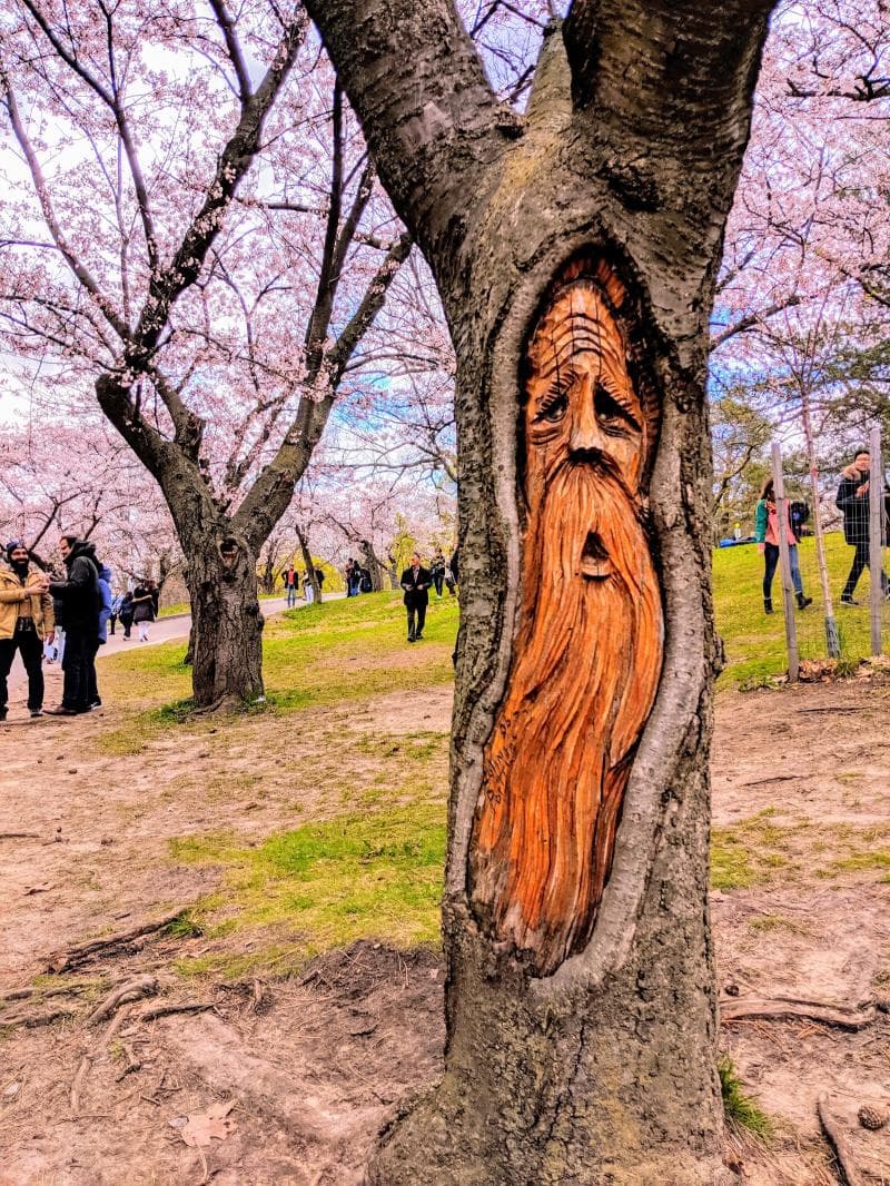
Another beloved annual event, though not directly on the hiking trails themselves, draws countless visitors near the trails: the blooming of the cherry blossoms. Gifted from Tokyo, these trees create a spectacular pink and white canopy, typically in late April or early May, along paths leading to Grenadier Pond and West Road. While busy during this period, the vibrant display offers a memorable experience. The park is also known for its 'Forty Fruit Tree' near Maple Leaf Gardens, an intriguing tree that produces various flowers and fruits from a single trunk, showcasing botanical ingenuity.
Visitor Perspective
For those looking to explore, the hiking trails of High Park offer a sense of wilderness within a major urban center. While some trails are paved, others are natural paths, traversing through mature forests and offering serene views across bodies of water. Maps are available to help navigate the park's extensive and often hilly landscape. It's advised to stick to designated sidewalks and formal trails to protect the sensitive natural areas, especially during winter when unpaved paths are not maintained. The trails cater to a range of fitness levels, from easy strolls to routes that require good fitness, making High Park accessible for most. Whether you're seeking a quiet escape to observe birds and wildlife or a vigorous walk surrounded by nature's beauty, High Park's trails provide a refreshing contrast to the urban environment.
Coordinates: -79.463, 43.6468
View on Google Maps💬 How Travelers Describe This Place
Based on community votes
Interesting
995Must See
989Unique
603Beautiful
581Photogenic
388
Traveler Stories
Discover memorable experiences shared by travelers who have visited this place.
No traveler stories yet.
Be the first traveler to share what made this place memorable.

Tour
By
Spot
Discover amazing places around the world. Your journey starts here.
Explore
© 2026 TourBySpot. All rights reserved.