Hiking Routes
Bergen, Norway
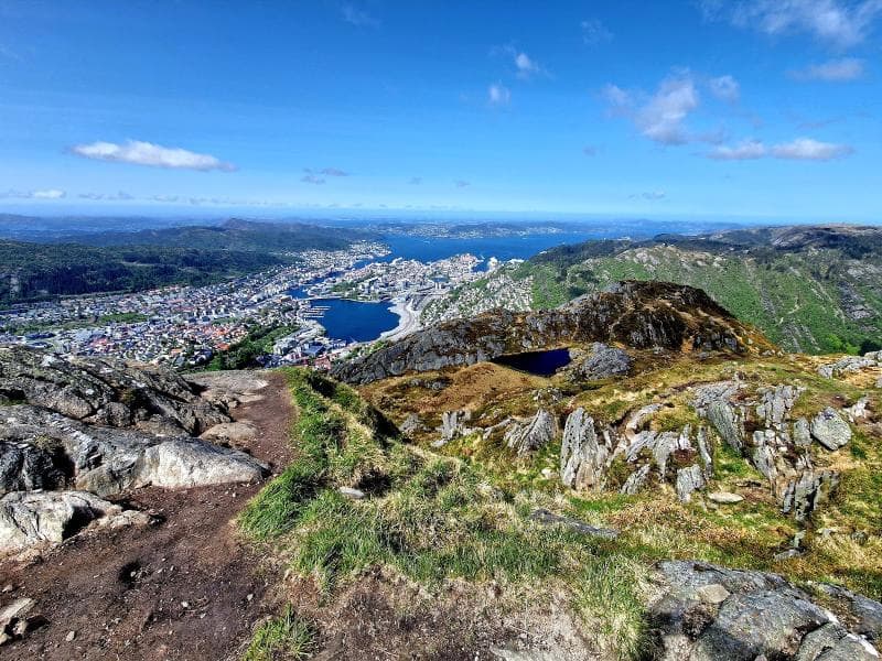
Explore Ulriken's hiking routes in Bergen, Norway. Discover Sherpa steps, scenic trails, and cultural history on the city's highest mountain.
Overview
Perched majestically above Bergen, Norway, Ulriken stands as the highest of the city's iconic 'Seven Mountains', reaching an elevation of 643 meters above sea level. This prominent peak is a cherished destination for both locals and travelers, offering breathtaking panoramic vistas that sweep across the city, the surrounding fjords, the vast sea, and the scattered skerries. More than just a scenic viewpoint, Ulriken is a gateway to a network of diverse hiking routes, each presenting a unique way to experience the wild beauty of Western Norway. Whether seeking a challenging ascent or a leisurely stroll, the trails of Ulriken promise an unforgettable connection with nature and stunning visual rewards.
History & Cultural Background
The history of Ulriken is deeply intertwined with Bergen's identity. Its name itself carries a whisper of ancient times, believed to stem from the Old Norse word 'Ullr', signifying 'to shine', or perhaps 'Ulfr' meaning 'wolf', hinting at its wild, untamed character or its historical role as a navigational beacon. Since the 19th century, Ulriken has been a popular destination, drawing adventurers and inspiring artists. A notable moment occurred in 1853 when the renowned playwright Henrik Ibsen himself hiked to its summit, later composing a song about the experience. Even earlier, around 1790, Bishop Johan Nordahl Brun penned Bergen's beloved city song, 'Udsigter fra Ulrikken', famously known as 'Jeg tok min nystemte', cementing the mountain's place in the city's cultural heart.
Today, the mountain continues its historical narrative with a modern touch. Many of its popular hiking paths feature expertly constructed stone steps, a testament to a unique cultural collaboration. These 'Sherpa steps' were meticulously built by skilled Nepalese Sherpas, part of a broader initiative in Norway to create and maintain durable mountain trails. This blend of Norwegian landscape and Nepalese craftsmanship ensures a safe and enduring passage for countless hikers.
Interestingly, one area on Ulriken's slopes, known as Isdalen, or 'Ice Valley', holds a more somber historical note. It has been colloquially dubbed 'Death Valley' due to a past marked by medieval suicides and more recent hiking accidents, gaining particular notoriety in 1970 with the unsolved mystery of the 'Isdal Woman'.
What Makes It Special
What truly sets Ulriken apart is its unparalleled combination of accessibility and wild grandeur. As the highest peak among Bergen's urban mountains, it offers the most expansive and dramatic views of the cityscape, the deep blue fjords, and the intricate coastline dotted with islands. The journey to the top, whether by the modern cable car or on foot along its challenging trails, feels like an ascent into a different world. The varied terrain, from the dense forests at its base to the exposed, rocky plateaus higher up, creates a dynamic hiking experience. The 'Sherpa steps' themselves are a marvel of engineering and a unique feature, providing a structured yet demanding path to the summit while offering integrated benches for rest and contemplation amidst the climb. Furthermore, the opportunity to embark on the classic 'Vidden' traverse to Mount Fløyen, connecting two of Bergen's most famous mountains, offers an extended adventure through breathtaking and ever-changing scenery.
Stories, Fun Facts & Local Details
Locals have long held Ulriken in high regard, considering it more than just a mountain; it is a landmark and a source of civic pride. The mountain was famously featured in a 2016 music video by DJ Alan Walker, 'Alone', showcasing its dramatic landscapes to a global audience. For many, conquering Ulriken's summit is a rite of passage, a challenge rewarded with a sense of accomplishment and awe-inspiring views. At the top, beyond the physical exertion, awaits the modern Ulriken Cable Car station, boasting a restaurant, a café, and a spacious viewing platform. Here, you can savor a traditional Norwegian 'fjellmeny' (mountain menu) or a warm beverage, taking in the vistas that stretch endlessly into the horizon. Free telescopes are available for visitors to zoom in on distant landmarks and truly appreciate the intricate details of Bergen's surroundings.
For those interested in an extended adventure, the Ulriken to Fløyen 'Vidden' hike is approximately 13 kilometers (8 miles) and typically takes around five hours. This traverse is particularly popular, offering a continuous journey through varied nature and exciting sights, including the Human Rights Cairn at Storefjellet. Many prefer starting from Ulriken and walking towards Fløyen, as it is generally considered a gentler descent, concluding conveniently close to Bergen's city center.
Visitor Perspective
Hiking Ulriken is an accessible adventure for most, though preparation is key. While many routes are steep, they are generally suitable for both adults and children with a reasonable fitness level. The most popular ascent route features the 1,333 'Sherpa steps', which can be challenging, particularly for knees, so bringing hiking poles is often recommended. The trails are well-marked, especially the 'Oppstemten' path starting from the lower cable car station or Montana. For those who prefer a less strenuous climb, the 'Skiveien' path offers a longer, less steep alternative.
Visitors can choose to hike all the way up, take the Ulriken Cable Car for a swift ascent, or combine both options, perhaps hiking up and riding down. The cable car operates regularly, and shuttle buses are available from Bergen city center to the cable car's base station, making access straightforward. Public transport via Bergen Light Rail (Bybanen) or local buses also provides convenient connections. It is important to dress appropriately for mountain weather, which can change rapidly, and in winter, ice spikes for footwear are essential on the steps. Free maps detailing the hiking area are often available at the upper cable car station, ensuring travelers can navigate the various trails with confidence.
Coordinates: 5.3586, 60.3731
View on Google Maps💬 How Travelers Describe This Place
Based on community votes
Unique
886Interesting
564Must See
443Beautiful
233Photogenic
201
Traveler Stories
Discover memorable experiences shared by travelers who have visited this place.
No traveler stories yet.
Be the first traveler to share what made this place memorable.

Tour
By
Spot
Discover amazing places around the world. Your journey starts here.
Explore
© 2026 TourBySpot. All rights reserved.